

Today is the day! At 2:30 a.m. my alarm goes off.
There is an awesome night sky and the moon gently lights the scenery. While tearing down my tent and packing up things I try to avoid making too much noise or shining my headlight on the other tents.
I hope that I’m not forgetting anything in the dark. But this my the last day on the trail, so it wouldn’t really matter anyway. When I get started at 3 a.m. I walk over to Lars to wake him up as well. But either he has already left or I just can’t find his tent in the dark…
I am pretty much alone on the trail, I only see a few headlamps way before me. As I get higher, more and more lights turn on at Guitar Lake and start moving towards Mount Whitney.

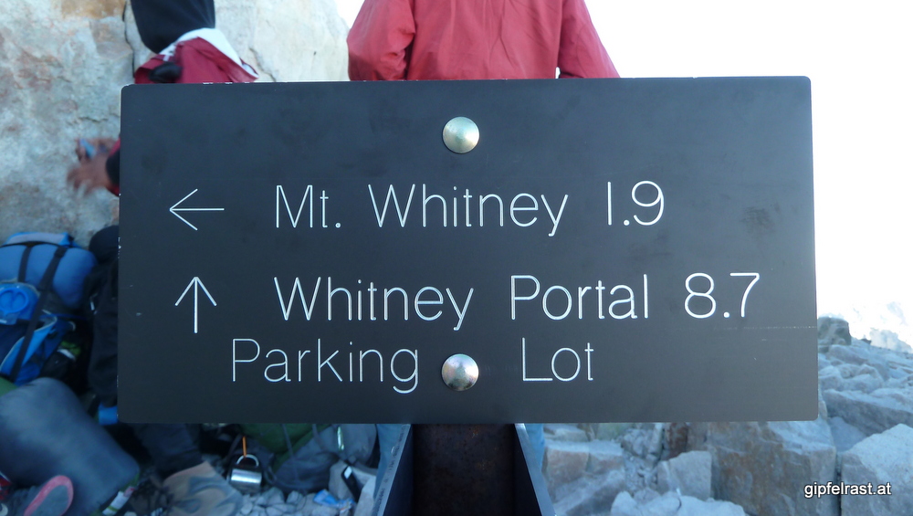
When I reach the Mt. Whitney junction – the John Muir Trail unites with the Mount Whitney Trail coming up from Whitney Portal – I am baffled by the signpost: PARKING LOT 8.7 MILES.
No way I’m going to a f***ing parking right now!
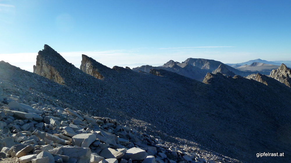
Less than two more miles to the summit! The trail is flat, even downhill for a while but very rocky, I have to take care to not to stumble. When passing the notches between the peaks neighbouring Mt. Whitney, the view opens up to the East. I can see the beginning sunrise and the lights of Lone Pine.

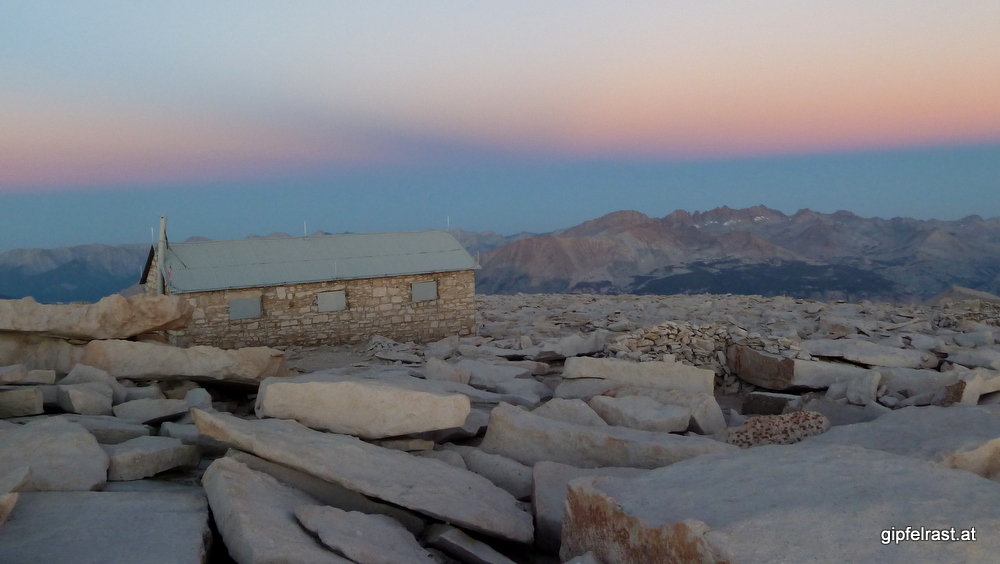
Then, finally, the summit is close and I spot the hut on top of the mountain. The last minutes before the summit are very emotional. After all those miles – this is it!

On the summit it’s just wooooooooooooow! Awesome, I’ve done it!
Lars and to my surprise also Frederick are already here and are watching the daylight coming from the east. Frederick could not sleep and started hiking an entire hour before I did.
At this early hour it is very cold and windy, some people are sitting here wrapped in their sleeping bags.


Standing there gazing at the rising sun I can’t help but raise my Nalgene bottle and utter some words that have formed in my head during the final approach to the summit.
Here’s to John Muir!
Here’s to all who worked to create and maintain this wonderful trail!
Here’s to all who help to preserve the beauty of the Sierras!
Here’s to all who I met on the trail who made this trip such an enjoyable experience!
And most of all – here’s to all my friends at home, who probably think I’m dead by now because I haven’t been able to call home for nine days!
Speaking of calling home, I finally check for mobile phone reception. Hmmm, nothing? A bit disappointed I put the phone back into my pocket but after a few moments: Beep-beep – beep-beep!
Ha, for sure a message from my loved ones! Nah, just my provider notifying me about my monthly bill – which by the way skyrocketed due to roaming charges. Ha ha, very funny…


So I finally get to text my family and a few friends – I admit, I’ve pre-written it yesterday evening knowing it would be too cold on the summit – to let everybody know that I’m alive and well:
Wohoo! Just summited Mt. Whitney! End of the JMT, so happy I made it, bit sad it’ll all end tonight. Liebe Grüße, Gert
As the responses are coming in I finally find a place with good enough reception to call home, it feels very good to hear those voices!


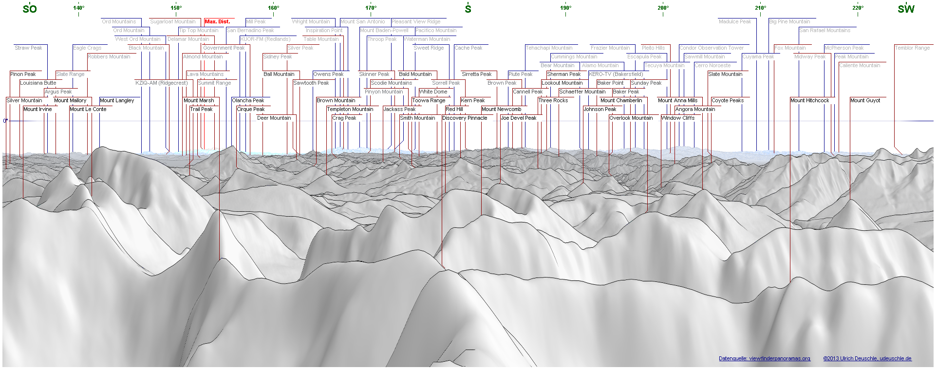
Here is an overview on all the peaks that can be seen from the summit. The panoramas were created with Panorama Maker by Ulrich Deuschle. Click to enlarge.


I’m almost two hours on the summit but at one point I have to leave. My JMT thru-hike is over, all I have to do now is hike down to Whitney Portal. A knee-shattering decent of about 2000m is waiting for me…

Back at Whitney Junction I meet Rob, Peter and John who are just going to the summit. After a short ascent to the last pass on my hike – Trail Crest – I sit down and have another break in the sun. Meanwhile it is very warm.
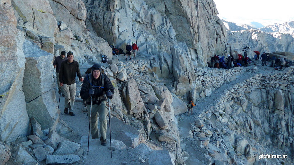

I now meet a lot of hikers coming up from the Portal who climb Mount Whitney as a day hike. Lots of the hikers are ill-equipped. Some of them are hiking alone without any backpack (water!) or are wearing blue jeans.
I meet a father with his boy who is apparently altitude sick and puking his soul out. I suggest they better turn around, but as I continue down, I can’t see if the father accepts my advice.


When walking down the endless switchbacks I am very happy that I did not plan a northbound JMT-hike. Starting with this climb without being acclimated must be a tough thing. I definitely do not envy the day hikers…

On the way down I pass the only camping opportunities for Mt. Whitney hikers – the crowded Trail Camp and the empty Outpost Camp.


After a nine hour hiking day, most of it downhill I finally arrive at Whitney Portal around noon. Straight away I go to the portal store, order my well-earned burger and this is THE END!

Distance hiked on JMT: 4.6 mi / 7.4 km
Distance hiked off JMT: 13.0 mi / 20.9 km
Elevation gained: 3800 feet / 1150 meters
Time spent hiking (including breaks): 9:05 h
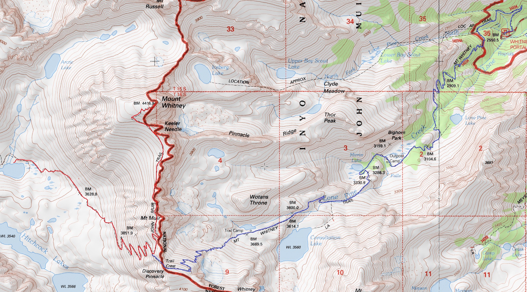
Maps of Day 19 (red = JMT, blue = other trails):
Hi Gert! I finally found the time reading through your blog as well… O waw, seems like you had an as amazing hike as I had!!! Great pictures too!!! Congrats on your thru-hike!!!!!!!!! And happy trails for the future!!! Take care! Cat!
Followed your link on the JMT Facebook page! Great job!!
Hallo Gert, sehr interessanter Bericht! Eine Frage: Wie bist du von lone pine nach LAX zurückgekommen? Es gibt ja einen Bus nach Lancaster. Aber wie kommt man von dort zum Flughafen? Ich habe eine Permit für heuer Start 11.8. Und bin schon sehr gespannt. .. Schöne Grüße Chris
Wenn du’s mal nach Lancaster geschafft hast ist’s einfach: von dort fährt ein Zug (Metrolink) nach LA Union Station. Da kannst du direkt in einen Bus nach LAX umsteigen!
Auf den Bus von Lone Pine nach Lancaster hab ich aber 2 1/2 Tage warten müssen… 😉
Wünsche dir viel Spaß am JMT!